

 Share This Page
| Home | | Planetary Science | | | | Share This Page |
Portions Copyright © 2015, P. Lutus. All rights reserved. Message Page
(double-click any word to see its definition)
In connection with my recent work with photospheres as a method to represent real-world camera data acquired with a drone, it occurred to me that this same technology could be applied to planetary image data, much of which happens to be available in the same equirectangular format that has become the de facto standard for photosphere data.
Here is a link to the the source of the Mars surface image data, along with an in-depth explanation of its origins. I emphasize that the Mars imagery is in the public domain, my copyright protection only covers this page and the photosphere viewer.
The Mars terrain data on this page are in the public domain, and appear courtesy of NASA, the Jet Propulsion Laboratory, Arizona State University, and the USGS.
On this page the Mars imagery is provided in three forms: A video in which natural-color terrain data is mapped to a sphere, a natural-color terrain photosphere, and an elevation photosphere with elevations indexed by color.
This video was created in the Blender graphic modeler by mapping to a sphere the same Mars terrain data used to produce the photosphere shown below on this page. The video is encoded in anaglyphic stereo
.
Phony Phobos
In the computer animation below, the Mars rendering is quite accurate, relying as it does on a detailed photographic Mars map, but the satellite visible in the animation is only a rough approximation of Phobos, and it's present only to add some depth and variety to the anaglyphic projection. Its orbital period isn't close to that of the real Phobos — it's been set to ½ the orbital period of Mars, just to allow the animation to repeat seamlessly after 360 frames (15 seconds at 24 frames per second) with all its elements in alignment. Phony Phobos' orbital radius is set to 2x that of Mars itself, only to make it more visible (the real Phobos has an orbital radius 2.77 times that of Mars, measured from the center of Mars). Finally, Phony Phobos is larger and brighter than the real thing, after I discovered that an accurate rendering of Phobos would be almost invisible at this model's scale.
I add these notes because, if I didn't, a visiting planetary scientist would surely point out how distant from reality Phony Phobos was.
In the photosphere below, Martian natural-color terrain surface data is displayed in an equirectangular projection, 21,340 by 10,670 pixels in size, each pixel representing approximately 1 kilometer of the Martian surface.
The photosphere viewer provides a Martian latitude and longitude readout, using the "east longitude system," the system in use since 2002, in which 360 degrees of longitude are counted eastward from the prime meridian.
To use the viewer, drag your mouse pointer on the image to pan horizontally and vertically, and use your mouse wheel or the '+','-' buttons to change magnification. And for more immersion in the Martian landscape, notice the full-screen button at the upper left.
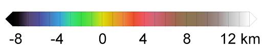
In the photosphere below, Martian elevation data, coded as colors (see key below), is displayed in an equirectangular projection, 15,000 by 7,500 pixels in size, each pixel representing approximately 1 1/2 kilometers of the Martian surface.
The photosphere viewer provides a Martian latitude and longitude readout, using the "east longitude system," the system in use since 2002, in which 360 degrees of longitude are counted eastward from the prime meridian.
To use the viewer, drag your mouse pointer on the image to pan horizontally and vertically, and use your mouse wheel or the '+','-' buttons to change magnification. And for more immersion in the Martian landscape, notice the full-screen button at the upper left.
Latitude: 0.000 Longitude: 0.000 Mars elevation photosphere, about 1.5 km/pixel (imagery source)
Elevation key:
These images are very large, too large for most photosphere viewers if displayed as a single image. In the most recent version of this project I have adopted a viewer named Pannellum that's able to load a photosphere in sections (tiles) to save memory and a visitor's time. This change represents a big improvement in the performance of this page.
| Home | | Planetary Science | | | | Share This Page |